Attractions
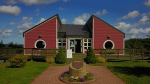 Bay Roberts Visitor Information Centre
The Visitor Information Centre is open year round with varying hours. After the tourism season winds down, the centre is the venue for many community events. Pumpkin Fest take place in October at this brighty decorated setting. In November there have been a variety of events, art shows, book launchings, presentations etc. During the “Festival of Lights” the building transforms into the Christmas Chalet. There are Pictures with Santa, Storytime, Cookie Decorating and Craft Time for Pre-schoolers. Community Sing-a-long and many families and weddings come in to do pictures. The centre is available for rental.
Lois Dawe, Tourism Officer
t: (709) 683-6377
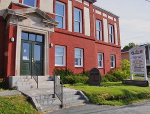 Cable Building National Historic Site
The Cable Building in Bay Roberts is a National Historic Site of Canada as well as being a Provincial Heritage Structure. Today it is still a key location in the town of Bay Roberts since it contains the Bay Roberts Town Hall (including council offices, meeting rooms, and the Council Chamber on the ground floor) and the Road to Yesterday Museum, the Christopher Pratt Gallery, and the Town Archives on the second floor.
Road to Yesterday Museum
Most people who visit the Road to Yesterday Museum, which was developed and is operated by the Bay Roberts Heritage Society, are amazed at the quality of the artifacts and the displays. Although the focus of the Museum is the turn of the century mercantile history of Bay Roberts, the Museum also contains displays about the early history of the Town. Many artifacts were donated by the families of business owners.
Christopher Pratt Gallery
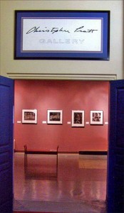
The Christopher Pratt Gallery is acclimatized and is designed to display a permanent collection of artwork, including works by Christopher Pratt. In addition, it hosts the works of well known local artists and visiting art collections. Christopher Pratt, perhaps Newfoundland and Labrador’s most widely recognized visual artist, has roots in the town. Christine (Dawe) Pratt, his mother, was born in Bay Roberts.
By 1913, the current Cable Building in Bay Roberts was built to serve as the main relay between the North American and European networks of Western Union Telegraph. Its establishment was a key component in the company’s international strategy and its architectural design is important corporate evidence of the expansion and dominance of Western Union in Newfoundland. The design of the Cable Building also introduced a new type of telegraph station to Newfoundland as it adopted the Western Union Telegraph corporate model. The architecture demonstrates a functional and specialized layout with rooms dedicated to specific equipment, technical operations, and administration. From its technical design to the connecting cables, the Cable Building was a flagship of telegraph technologies, illustrating Western Union’s important role as an innovative industry leader.
For information about our museum and art gallery, please contact the Bay Roberts Heritage Society:
bayrobertsheritagesociety.com
bayrobertsheritagesociety@hotmail.com
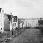
Cable Avenue Municipal Heritage District
 Cable Avenue dates back to 1913, when construction of staff housing by the Western Union Telegraph Company began along the street. The designation includes the houses on the east and west sides of Cable Avenue, the house on the corner of Cable Avenue and Water Street, Western Union Cable Building on Water Street and the grounds associated with these structures. Other principal physical elements of the district include the set-back sidewalks, curbs, original streetlights and the chestnut trees which line the street.
 Bridget (Bride) Fitzpatrick, of Bay Roberts, was one of only eight female Canadian and Newfoundland mariners who lost their lives due to enemy action during the two world wars. Her remains are interred in the Roman Catholic cemetery adjacent to Cable Avenue.
Shoreline Heritage Walking Trail
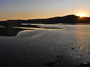
The 8 km Bay Roberts Shoreline Heritage Walking Trail, which was developed by the Bay Roberts Heritage Society, offers an opportunity to pay honour to the past, while communing with nature away from the noise of today’s world. The coastal walk wanders along sheer cliffs, sweeps of beach, sheltered coves, and craggy headlands. From cliffs, coves, beaches, and headlands see whales follow caplin, squid, and other fish into the bay, especially in June and July. Trail users can also observe seabirds and bald eagles, and examine different types of wildflowers.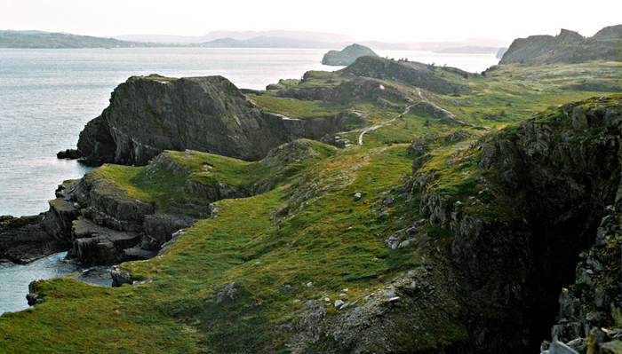
The Trail is located at the tip of the Bay Roberts Peninsula and has three different spectacular views of Conception Bay. From the South East side where Fergus Island is located, Coley’s Point, Bareneed, and Port de Grave are in view. From the Eastern tip where MadRock is located, CBS, Bell Island, Harbour Grace Island, and Upper Island Cove can be seen. From the North side at the Three Sisters, the Shearstown Estuary, Spaniard’s Bay, Bishop’s Cove, and Upper Island Cove are in sight. Even people with limited mobility can access many parts of the Trail by car and enjoy the view to the North, South, East and West.
|
|
|
|
|
|
|
|
|
|
|
|
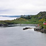 Bishop’s Beach & Mack’s Beach are near the beginning of the Walking Trail and can be accessed from the Crane’s Hill Access Point or the French’s Cove Access Point. The refurbished Red Fishermen’s Shed near Mack’s Beach is the site of a number of community events.
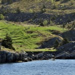 French’s Cove and Juggler’s Cove, with histories going back to the late 1500s and early 1600s, are calm, sheltered places. French raids by Pierre LeMoyne d’Iberville in 1697 and Jacques Testard de Montigny in 1705 destroyed the communities; however, the English settlers quickly rebuilt. French’s Cove is named after the Edward French family who claimed land here going back to 1634. The remains of a fishing settlement are barely visible to the eye today. Imagine it as it must have looked 300 years ago.
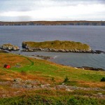 Juggler’s Cove may be considered the birthplace of Bay Roberts. Occupied in the late 1500s and settled in the early 1600s, it gets its name from the dexterity needed (that of a juggler) to navigate into the cove.
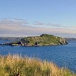 Fergus Island is named after Scottish merchant John Fergus who carried on a large supply business in 1812. The island viewed from French’s Cove depicts the image of a Newfoundland dog at rest.
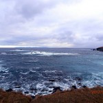 At Madrock, the many moods of the true Atlantic coast are experienced, including soft mists, warm sunlight reflecting on still waters, or full-blown Atlantic storms with its massive breakers exploding against the rocks. The reason for the name “mad rock” becomes clear to anyone who experiences the surf pounding the shore.
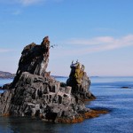 The Three Sisters provides a pebble beach where visitors can picnic and enjoy the view. During the capelin scull, thousands of caplein roll onto the beach. People catch the little fish with nets, dip nets, and sometimes with their bare hands!
The Shearstown Estuary
 Bay Roberts and the Town of Spaniard’s Bay were awarded the 2009 Torngat Municipal Achievement Award in the category of Environmental Sustainability, for their joint efforts on the Shearstown Estuary. The Estuary has a number of walking trails as well as wayside signs which describe various species of plant and animal life.
The Shearstown Estuary is a shallow body of water where freshwater from Shearstown River meets and mixes with saltwater from Spaniard’s Bay. The resulting mixture of water is termed “brackish,” or partially salty. Shearstown River, Shearstown Pond, Muddy Hole Road, Arnie’s Pond and the shallow inner reaches of Spaniard’s Bay comprise the Shearstown Estuary. The salinity, or saltiness of the water, varies considerably throughout the estuary with time and location and is dependent on tides, winds and precipitation.
In 1997 the towns of Spaniard’s Bay and Bay Roberts signed a Municipal Stewardship Agreement, making the Shearstown estuary an important link in wetland conservation in North America. Through this agreement the towns agreed to manage wetlands within their jurisdiction with technical advice from the partners of the Eastern Habitat Joint Venture. The Municipal Stewardship Agreement is unique in the province since it is the only one where two municipalities are cooperating to preserve a wetland.
The Shearstown Estuary is governed by a Joint Management Committee, which is made up of two members from the Town of Spaniard’s Bay and two members from the Town of Bay Roberts. For more information, contact:
Cathy Kleinwort, Chair of the Joint Management Committee
t: (709) 788-9464
cathykleinwort@eastlink.ca
shearstownestuary.ca
Veterans Quay Marina at Royal Canadian Legion
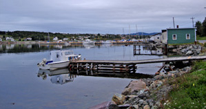 Royal Canadian Legion, Branch #32 with its attached Veteran’s Quay Marina is one of the most attractive facilities in the community. The Legion Club hosts a number of community events.
The Veterans’ Quay is right in the heart of the town of Bay Roberts. It offers electrical hookups and drinking water supplies, as well as a wooden slipway or boat launch. The marina currently has 400 feet of landscaped waterfront property from the Klondyke Causeway to the boat launch, plus a 300-foot apron behind the Legion with two finger piers and a number of floating docks. Off one of the finger piers lies the visible remains of a 19th century schooner believed to be the “Hebe.”
The Quay had its grand opening on September 25, 1999. A percentage of the work on the $2.3 million dollar project was contributed. Eric Jerrett contributed the design work and deals were made with companies such as Newfoundland Power, NewTel Communications, Newfoundland Hydro, and Pennecon Ltd. to provide materials either free of charge or at bargain prices. The Bay Roberts History Board was contributed by the Johnson Family Foundation.
Book anchorage at the Veterans’ Quay
t: (709) 786-2075
Contact the Royal Canadian Legion Club
t: (709) 786-2075